I almost forgot to mention. On Saturday morning, I crossed the 200 mark!
Tag Archives: geocaching
ApacheCon planning
With 214 responses to the ApacheCon RFP, about half of them coming in the last week, we’re gathering in NYC to select which ones will be in the show, as well as put together the schedule.
I discovered on Wednesday that even though I was badgering other people to submit talks, I myself had forgotten to submit any talks. Great. I managed to sneak a few in, though. 🙂
I really don’t like New York City. It is loud, too bright, crowded, and people just aren’t very nice. On the bright side, we’ll be so busy that we’re unlikely to get out of the hotel much. We’ll be on South William Street, wherever that is. Looks like there’s a few geocaches in the area, so maybe I’ll nip out one of the evenings and look for a couple of those. If it’s not too miserably cold.
Repairing a cache on “Black Friday”
I was planning to go out to one of my caches (“Wile Blue Yonder”) and fix it today. However, I just realized that, in order to do that, I’ll have to wait in traffic for about an hour, since it’s out towards the largest shopping center in the city. This is rather distressing to me, since I have a *great* idea for repairing it, and I would be very disappointed if I don’t get it done today. Maybe I’ll just put up with it and head out there anyway.
ApacheCon Cometh
We’re coming down to the last few days before ApacheCon. We’ve broken the mystical 300 barrier on registrations, but there’s still room for a lot more of you. I’m starting to get a little bit excited/nervous about the conference. I’m speaking 6 times, which, I assure you, is a clear sign of insanity. Or at least will lead to it.
You also should take a look at the ApacheCon Wiki, which should be picking up steam in the next few days. And you can probably virtually “attend” the conference on IRC, on #apachecon, on freenode.net. Not the same as being there, but still pretty fun.
Oh, and if you want to go GeoCaching at the conference, please, please, please let me know. It would be great to have some company.
Apache training ending
Today’s the last day of Apache training. It’s been a pretty good week, with most of the usual annoyances, and a few more, but overall a good class.
Unfortunately, most of the students were not actually released from their work duties when they were sent to training, so they wandered in and out all week, missing an hour here, a half day there, and, in several cases, an entire day or two. Employers, don’t do this. You’re wasting your money, and your productivity, when you send a student to training and then don’t actually allow them to attend it. In several cases, folks missed the things that they were most interested in hearing about. because the were called to a meeting at just that moment.
I tried to go geocaching a few times, and I actually found one cache, but for the most part I just didn’t seem to have the passion for it. I went to one cache which looked kinda interesting, but when I got there, it turned out to be a multi, and I just couldn’t work up the interest to do the whole thing. Kinda pathetic, I suppose.
I’ve been driving a Pontiac Sunfire, and I really miss my Jeep. The first morning when I pulled into the parking garage, it took me a moment to figure out how to open the window. I reached back for the zipper, and there wasn’t one! Also, the car doesn’t have a clutch, which is a bit disconcerting.
I’m *so* ready to go home.
Oh, yeah, and last night I went to the party on Clematis street. Every Thursday evening they block off a few streets and have live music and food stalls, and vendors. It was kinda nice. One of the vendors was from Kenya, and had a bunch of Kenya art and carvings. It was nice to talk to them, although they didn’t really want to talk for some reason. Oh, well.
An afternoon in the mountains
This afternoon I had the unexpected, and completely unplanned, pleasure of spending several hours with my aunt in the mountains of eastern Ky. I was in Jackson, Ky, for reasons not worth mentioning in the public record. When I got done there, it was just 3:15, and the most beautiful day one could hope for. Since I was just a few miles from KMBC, I decided to drop in and visit for a few minutes.
I ended up staying for about 3 hours, and I’m really glad I did. Things move at a slower pace up there, and it was very, very nice.
My aunt went geocaching with me, as she wanted to see what was actually involved. Turns out that the cache in question was exceedingly easy. When we got there I said “Well, if *I* was going to hide this, I’d put it …” and I reached out and grabbed it. 🙂 But at least she got the general idea.
Then, I stayed for dinner. The board of trustees was there, and so apparently I picked a very good day to visit. Dinner was excellent, and the company was even better. After dinner, the college choir sang, and they were excellent, too.
In all, although not how I planned to spend my afternoon and evening, it was by far the best thing. Very enjoyable, and relaxing.
Oh, and I got to meet Romeo, too. 😉
A candidate for sainthood
I’d like to nominate for sainthood the bloke who thought it would be a good idea to throw some tincans up in the air and have them tell us where we are. The Global Positioning System is one of the top hundred inventions of the last 100 years. I think I’d put it right up there with the Internet.
Of course, if it wasn’t for the Internet and the GPS, I would not be lost deep in the woods …
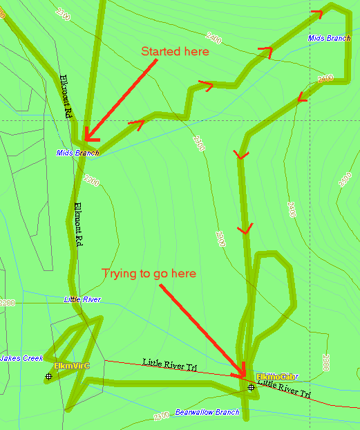 The image displayed here shows me walking in (I believed) a straight line, between about 12:15pm and 1:55pm today. The point at which I decided I was lost is left as an exercise for your imagination. This is the backtrack from my GPSr, intermittently losing contact with the satelites, so you can assume that my actual path was even more circuitous. (Note: I changed the image a few times, because I wasn’t sure I had the right part of the track. I’m certain I have the right bits now.)
If you read the book “The Girl Who Loved Tom Gordon”, and didn’t understand why it was scary, here’s a few friendly tips for you.
When you’re lost in the woods, everything looks like a trail. Right up to that “Dear God I’m going to die in here and they’ll find my bones next spring” moment. Then nothing looks like a trail, even if it has a yellow center line. So don’t leave the trail, because you won’t find it again.
If you believe, as I once did, that carrying a GPSr ensures that you cannot ever get lost, make sure you take your cell phone with you. You’ll find that you get the best signal if you climb to higher ground.
When you’re deep in the woods, the GPS starts lying to you. For a time, it will tell you that the destination is 300 feet ahead of you. Then it will say that it’s 2 miles behind you. Then it will stubbornly refuse to tell you anything at all. Then, suddenly, you’ll crest a hill, and it will tell you that you just fought your way 500 feet through thorns in the wrong direction.
When you’re lost in the woods, all spiders are poisonous, and even pinecones can transform themselves into rattle snakes. Don’t ask me about the mechanics of this. I think it’s covered in “Tom Gordon.”
0.15 miles is approximately 750 feet. This may take you about 3 minutes to walk on flat uninterrupted ground. When you are lost, this may take more than an hour, because you are incapable of maintaining a straight line for any distance, and although you are certain that you are correcting back to the straight path after going around an obstacle, you’re wrong.
And, if you missed the other tips, here’s the important one. Never leave the trail. Never leave the trail. Never leave the trail.
Ok, that was a *REALLY* scary hour. Or was it just 20 minutes? I’m really not sure.
Then, suddenly, you emerge back onto the 4-foot-wide pave trail, with startled pleasure-walker tourists and their kids in strollers, looking with mild curiousity at your wild eyes and soaked-to-the-waist jeans, and it all seems vaguely silly and not worth talking about. “Oh, don’t mind me. I just spent the last 2 hours – or was it 15 minutes – in terror and certain that I’d be eating leaves and grass by sundown.”
Sheesh.
Oh, and just so there’s no confusion, I *did* find the cache, and logged it. So there. Nyeah.
Attempting to catch up
Here’s a bit of an attempt to catch up. Having been offline since Friday, there’s plenty to catch up on, and I’m afraid I’ll miss something. Oh well.
Friday, after the conference was officially over, I had a liesurely lunch with Ken, after which I took a long nap. Wow was I tired. I tried to go out and read by the pool for a while, but there was a young’un out there who screamed without taking a breath for about an hour, before he was finally carted off to somewhere else.
I inquired about an Indian restaurant at the front desk, and walked down a few blocks to The India House for some very good chicken tikka and paratha. Mmmmm.
On Saturday morning, after a liesurely breakfast, I went off on my geocaching hike. I think that Saturday was about as close to a real vacation as I’m going to get any time this year. I walked about 1.25 miles to Washington Park, where I took some pictures. Also while there I visited the rose garden.
And I found 5 geocaches, most of which were actually very challenging.
I also found a wallet. I pulled a business card out of it, and attempted to return it to the address thereon, but he didn’t live there, so I took it to the police station. I think by that time I had probably walked 4 miles, but perhaps a little further.
While I was in the rose garden, my brother had called with the names and addresses of the various ethiopian restaurants in town, so after stopping by my hotel, I headed out for Mudai (45d32.0964,-122d39.44436). That was another 1.5 mile walk. Very enjoyable little hike.
On the way there I observed Flugtag, which was very odd. Strange people built flying machines (for a rather casual usage of the word flying) and drove them off of a 30-foot pier into the river. Very amusing. You should read about it on their website. I saw the Santa’s Sleigh team, among others. I even got a few pictures, although it’s a little hard to make out what’s going on.
Dinner at Mudai was fantastic. Just amazing. And well worth the hike. I was planning to get a taxi back, but the day was still so beautiful that I just walked back. Along they way I saw this Amazon.com advertisement on the side of a HUGE warehouse. Kinda funny. And that’s about it for Saturday. I have a remark to make about Sunday, but I’ll probably make that as another post.
Caching in Portland
I found some willing folks in the Press room, following my interview with OpenFoundry, and went geocaching. It was very warm outside, and we had to walk about a mile there. And then back of course.
This evening is The State of the Onion, and also Damian Conway’s Life, The Universe, and Everything. I believe I’ve seen this (latter) talk at least once before, but Damian is always worth going to hear.
Coordinates -> links
Here is my first attempt at a WordPress plugin. Coordinates that appear in a particular format get converted to a link to my cgi GPX generator. This is only the first proof-of-concept version. Hopefully the links will be more useful in the near future, including a link to a map of the area. The coordinte format is: xxdxx.xxx,yydyy.yyy where that’s a literal d, and the x and y are the latitude and longitude coordinates, respectively. Coordinates may be preceeded with – to indicate S and W, respectively.
Hmm. I wonder if I got longitude and latitude confused …
(Update: ok, there was a bug, but it seems to be fixed now.)
Please note that the code is largely cargo-culted from http://scott.yang.id.au/2004/05/scripturizer-for-wordpress/ and, as such, may contain one or more things that I don’t completely understand yet. I expect the code will improve as my understanding of it improves. Patches welcome. Code released under the HJTI license.